Orienteer Anytime
You don't need to wait for one of our organised orienteering events to go orienteering:
- Permanent Orienteering Courses have been around for many years. These are orienteering courses with fixed control posts throughout South Yorkshire. We don't manage these ourselves, but do our best to maintain a list of course courses here.
- Smartphone Orienteering (also known as Virtual Orienteering) has recently grown in popularity, especially during the pandemic. This is where you have an orienteering map on your smartphone and use this to complete an orienteering course - whenever works best for you. More details on how to do this type of orienteering can be found later on this page.
Find Your Way
Currently, we are participating in British Orienteering's Find Your Way project. For this we are running free organised orienteering events at different locations in Rotherham where you will be able to try standard orienteering (i.e. with a paper map), with help from our members. Then, after you have finished, we introduce you to smartphone orienteering so you can come back to the same area and orienteer whenever fits best for you. To see our Find Your Way events, head over to our organised orienteering events page and look out for events with the title "Orienteering Rotherham - Give it a go!".
Smartphone Orienteering
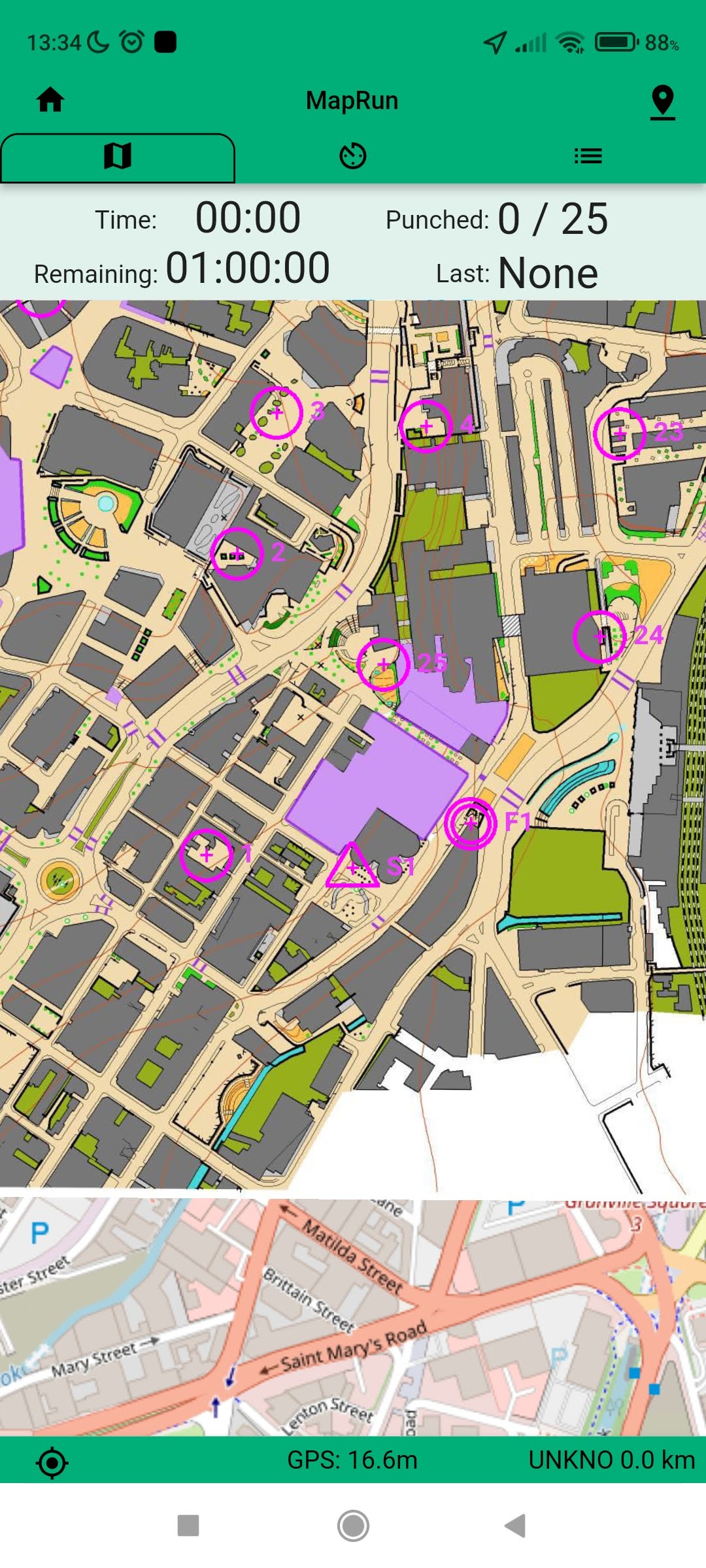
Virtual Orienteering Courses (VOCs) use smartphone technology to enable you to physically go orienteering without there being real controls to find. This is by no means a replacement for 'real' orienteering, but MapRun courses enable you to explore the outdoors as a family or individual at a time convenient to you. Download the map, choose your route and then run, jog or walk at your own pace to the control points and the app will notifiy you when you reach the correct location!
More information for first-time users is given at the bottom of the page - these courses are FREE and open to all! If you have any questions, comments or want technical advice, please don't hesitate to
Safety - Please note that this is not a British Orienteering insured activity and it is undertaken at your own risk. Take care crossing roads, especially on the Urban courses. If you go alone, please let someone know the details. Please be really courteous to any member of the public you come across, giving them right of way. Enjoy!

Establised for SYO's 50th anniversary, The Round Sheffield Orienteer comprises 8 orienteering course stages on MapRun, following the route of the 15 mile Sheffield Round Walk. Stages may be completed all in one go (The Full Monty), or in several sessions.
MapRun Locations
We have over 40 courses available in a great range of areas: from moorland like Redmires and Burbage, woodland like Tankersley and Sandall Beat, parks like Bolehill and the Porter Valley, to a variety of urban scores in Sheffield's City Centre and suburbs.
The pins on the map below show where we have MapRuns available. Clicking on a pin gives more info about the courses available, as well as a link to a PDF map of the course, and results of those who have already completed the course. Note that the various Stages of the Round Sheffield Orienteer are not shown on the map below - they should be accessed via the dedicated RSO Website.
Top Tips
- Make sure your phone has enough charge (GPS can be quite thirsty!), and sleep settings won't close the app/GPS during your run
- You don't need data/WiFi whilst you run - only to download the map before, and to upload your result at the end. Especially for the more rural events, consider downloading the map in the app before you leave home - there might not be data at the start! Your result is saved to your phone, so can be uploaded at any point.
- Ensure you have your sound nice and loud - so you know when you've got to a control
- You could use the map in the app to navigate - it can be useful as it shows your location if you get lost! But if you'd prefer the authentic experience of a real paper map, you can print your own (link to download map is in event info)
- Sometimes there is a bit of delay in the 'beep' once at a control site - GPS can lag slightly, and it may not be entirely accurate.
- Start at the Triangle, then go to the controls (either in the fixed 'linear' course order, or in any order if doing a 'score' - see 'Which type of course?' below), and then Finish at the double circles!

Getting Started
MapRun is FREE and easy to use.
To start your adventure, install the 'MapRun' app for iOS or Android:
- Choose a location via the map above. In the pop-up that appears when a pin is clicked, select the green Full details button, to see more info about the different courses available at that location
- The Get map link enables you to download a copy of the map for printing
- Clicking on the MapRun Link on your phone will open up that course in the MapRun app (it can take up to 30 seconds to load)
- You'll need WiFi or data to download the course to the app - but by loading it before you head outside, this means you don't need to use any mobile data (the app just needs GPS when you're actually running)
- Check your Name and other details are entered in the User Profile on the app
- You're now ready to start your MapRun!
We offer 2 types of courses: Linear (normal) or Score. Details of what courses are offered at each location are given in the map and list.
In a Linear course you must follow round all the controls (checkpoints) in order, going from the Start (Triangle), to 1, 2 3 etc. all the way round to the Finish (Double Circles). With the MapRun app you'll get a beep every time you reach a control. Your time starts at the Start, and ends at the Finish. On MapRun, we've planned a number of relatively easy Yellow courses in some of Sheffield's parks, that stay just on paths or well-cut grass. There's also the odd White course which is easier and shorter than a Yellow.
Contrastingly, in a Score you've got to plan the best route to try and visit as many controls as you can within a certain time limit. On MapRun it's usually an hour, but there are much shorter (and longer!) scores. You get 20 points for each control you find, but lose 10 points for every minute you are late back. Just like with the linear courses, your time still starts at the Start, and ends at the Finish - but what you do between these points is up to you! Top tip: don't run past the Finish until your ready to stop your time - otherwise the phone might think you want to end your course early!
The symbols used on an orienteering map are quite different from Ordnance Survey maps, and can take some getting used to.
To help you out, some maps (especially the Park ones) have a key (or legend) on the map - both in the app, and one you might print out. However some of the larger urban and moorland area maps may not have a legend, so use the following links to download a key to all the different colours and symbols used. Don't worry if it looks complicated at first, just concentrate on the main features of the map you're going to use - you'll soon have mastered them!
- If you've already loaded the course, tap Go to Start to see the map and course
- An alternative to loading the course ahead of time is to use the Events Near Me function in the app, once you are near the start point - but you will need mobile data for this
- You may need to 'Allow' GPS access
- The app will connect to GPS, and the status is given in the coloured bar at the bottom. It may take your phone a moment or two to locate enough satellites, in which case the bar will be red, indicating low accuracy.
- Once the bar turns green, you're ready to go!
- You then need to run or walk to the Start Triangle (on the map) to trigger your time to start!
- As you go round your course, make sure you hear a beep at each control - you may need to wait for a few seconds for the GPS to catch up if you're speedy! The controls will turn from pink to green on the map once punched.
- If you get lost, don't panic! The app shows where you are with a red dot :)
- At the end of your course (Linear or Score) pass through the Finish to stop your time. A screen will appear showing you your route and time.
- At the finish, MapRun will automatically upload your results (if you've got data), or you can do it yourself later (over wifi). You can also send your results to Strava. Please do upload your result, as it lets us know which courses are popular!
- Finally, you can compare your result with others who did the same course, by tapping All Results for this Event.
- Well done - you've completed a MapRun course!


