Regional Event
- When:
- Sunday 10 November 2024
- Where:
- Blacka Moor - Sheffield
- Category:
- Regional
- Results:
- View Results
- RouteGadget:
- View RouteGadget
- Splits Analysis:
- View Splits Analysis
- Ranking Points:
- View Ranking Points
Details
Results
Results, splits and routegadget for the linear courses are available via the links above. For Routegadget for the Score course, use the same link, click on Events and select the Score Course version.
Organisers comments
Thank you all for coming to Blackamoor, I hope everyone enjoyed the terrain and Jonny's courses. There were lots of nice comments at the finish, despite the steep run in, many route choices discussed!
I have a small black gillet if anyone left one at the finish. The dog's collar was returned to his owner. The control collecting team brought back lots of plastic, to save the cows from eating it but not the spade I found in the bracken.
Kind regards
Lucy
Final details update
Road Closure: Baslow road at Totley ( 1/4 mile NE of the event) will be closed from 1030-1115 for a Rememberence parade, please take a long alternative route if coming from Sheffield, local roads are narrow and likely to become blocked.
Key points of note: No dogs, 1.2km ( via the finish) to 2 adjacent starts, punching start, SIair enabled, use marked crossing points only. Be aware of deer/sheep/cows and other users of Blackamoor. Whistles compulsory, waterproofs may be - bring one with you. Bring money for hot drinks, cake & soup!
Very very limited entry on the day see below.
Description
Enjoy the challenge of orienteering on Blacka Moor - a mix of open moorland and woodland with great views. Full range of courses on offer to cater for experienced orienteers, younger juniors and newcomers. There is a score course for fell runners. The event is part of the YHOA superleague.
Parking
Parking on hard standing at the old Dyson's factory, off the A621 / Baslow Rd, 8km SW of Sheffield. Nearest postcode S17 3BL. What3words: moved.finishing.mason. GR SK 296790.
Car share or take public transport to reduce greenhouse emissions if possible.
Public Transport
The 218 Peakline service stops directly outside the assembly every 30 minutes. The full timetable can be found here.
The 97 arrives at the Gillfield Wood terminus, 300m walk from assembly. Service is approx once per hour. Timetable here.
It is a 50 minute cycle ride from central Sheffield.
Assembly
Toilets, enquiries and download at the Dyson's factory. The SYO juniors will be selling hot drinks, soup and cakes.
Entries
Please pre-enter via fabian4. Enter by Sunday 3rd November to guarantee your choice of map.
Entries will remain open until midday Friday 8th November subject to map availability. £2 surcharge per entry.
Very very very limited entry on the day There are a few Brown, score , all the greens bar light and white yellow orange maps but not many.
Adult £10 (£8 British Orienteering members). Adults on orange, yellow & white courses - £4.
Junior/student £4
Family £24 (£20 British Orienteering members). Family charge applies when family members are running different courses. If you are going round as a family group or pair, just pay for 1 entry.
Dibber (electronic timer) hire £1. Lost dibbers £30 charge.
Volunteers
Helpers are very welcome. Use SYOHELPER to get your 50% discount, available until 3rd November. Please
Courses
The age class categories are suggestions by British Orienteering but you are free to run whichever course you wish. To score in YHOA superleague you can still run whichever course you wish as the scoring system takes that into account.
Although the distances for Short Green, Green and Short Blue are similar the courses are across progressively more physically demanding areas and so winning times are expected to be in line with guidelines.
Score Course - There are 30 checkpoints. Find as many as you can within the 75 minute time limt. Each checkpoint is worth 10 points and for every minute (or part minute) you are late there is a 10 point penalty. This is a good option for those newer to the sport but want to run further than the distances offered by the orange / light green courses.
Provisional distances, subject to final controlling.
| Course | Length (km) | Climb (m) | Women's Classes | Men's Classes | Technical Difficulty |
| Black | 8.6 | 430 | M21 | Physically & technically difficult | |
| Brown | 7.7 | 350 | W21 | M20, M35, M40 | Physically & technically difficult |
| Short Brown | 6.3 | 330 | W20, W35 | M18, M45, M50 | Physically & technically difficult |
| Blue | 5.3 | 280 | W18, W40, W45 | M16, M55, M60 | Physically & technically difficult |
| Short Blue | 3.9 | 200 | W16, W50, W55 | M65, M70 | Physically & technically difficult |
| Green | 3.5 | 165 | W60, W65 | M75 | Technically difficult |
| Short Green | 3.4 | 110 | W70 | M80 | Techinically difficult. Avoids most physical terrain |
| Very Short Green | 2.7 | 50 | W75, W80, W85, W90 | M85, M90 | Techinically difficult. Avoids most physical terrain |
| Light Green | 3.6 | 125 | W14 | M14 | Medium-hard technical difficult. Adults with some navigation experience |
| Orange | 3.5 | 60 | W12 | M12 | Medium difficulty. Beginner Adults |
| Yellow | 2.7 | 70 | W10 | M10 | Technically easy. Good for families. |
| White | 1.8 | 55 | Technically very easy. Ideal for younger juniors. | ||
| Score - 75 minutes | Over 16s only | Over 16s only |
Starts & Finish
Starts from 1030-1230. Please select a 15 minute start block when entering. Courses close at 1430. You must retire if you are not going to finish by this time. Controls will be collected from 1430. Start early if you are going to take a long time.
There are 2 starts they are directly adjacent but have different start kites, Left start for Black, Brown and White, Right start for all other courses. White and Yellow maps will be available before the start grid.
The starts are 1.2km away with 100m climb. The route to the starts passes the finish ( at about 400m) if you wish to leave clothing there. We hope to provide a shelter tent at the finish. The route to the start includes one relatively steep climb and is about 70% on a taped route in terrain and 30% on a track (also taped) and nearly all in the open. It is possible you will encounter competing runners crossing you on the walk to the start and maybe even waiting at the start so please give way to those athletes.
The starts are in the open and may be exposed if weather is bad. It will be a punching start so there shouldn’t be a need to wait around too much.
The finish is 400m from Assembly. Please be very careful on the run in. It is quite steep down, singletrack and can be slippery. We will try and clear some of the sides to make room for overtaking but be wary of other competitors.
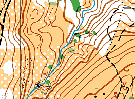
Map
1:10000 for courses Black to Blue & Score. 1:7500 for Short Blue to White. 5m contours. Partial update 2024 by Ian Cooper.
Terrain & Mapping Notes
The terrain is a mix of open moorland with varying runnability and a more wooded northern section. There are many hills and valleys so all courses have elevation changes.
As the bracken is still higher than hoped we have used the undergrowth screen symbol (vertical green stripes) to represent areas where bracken exists. This has not been accurately mapped and only is shown where we think it impacts the courses and not consistently across the whole map. It is not to be used for fine navigation but should aid with route choice. It has improved in the last month and you can get through it fine, it just might slow you down. There are many very small animal tracks in the terrain that have not been mapped. Only significant tracks are on the map.
Standing fences and walls are only to be crossed at marked crossing points. The course line will be diverted though or if there is a choice of points then there will be a gap in the line. Crossing points are a mixture of stiles, gates or sections of wooden slats. These boundaries are marked with a purple overprint.
Areas of out of bounds (vertical purple stripes) marked on the map must not be entered. Please pay particular attention on the score course where you will otherwise have free choice of route.
A previous map of the area can be found on SYO Routegadget:
Additional Safety Info
Full leg cover and whistles compulsory. Much of Blackamoor is above 1000ft and very exposed, please come prepared with a hooded waterproof jacket, hat and gloves. In the event of bad weather waterproofs will be compulsory. Notices will be placed on the entrance to car park to confirm. There are steep slopes, bracken, mud, rocks and other hazards, take care.
The area is shared with dog walkers, mountain bikers, horse riders, deer, cattle and sheep please be courteous and go around where necessary. The cows are generally docile but if unsure give them a wide berth. They occur in multiple parts of the area but may be where the White and Yellow courses go so parents please warn children.
The Dyson factory is available to us via Blenheim estates. It is no longer active and due for demolition so please take care. Do not enter any buildings unless clearly marked as part of the event, some areas may be taped off. Please ensure children are properly supervised and do not approach any areas that are not being used by the event. Use the toilets provided!
Thank you
Blackamoor is managed by Sheffield Wildlife trust and Totley moor by the Eastern Moors partnership. We thank both these organisation for their help.
Officials
Planner:Jonathan Crickmore SYO
Organiser: Lucy Wiegand SYO -
Controller: Dom Dakin SYO
Safety & risk
A comprehensive risk assessment will have been carried out by the organiser, but participants take part at their own risk and are responsible for their own safety during the event. If a competitor has a pre-existing medical condition that they think should be declared, please complete a medical form at enquiries. The sealed envelope will only be opened in an emergency.
Photography
SYO has an agreed policy on the taking of photographs at events, based on national guidance. This provides a sensible balance between the benefits and risks associated with the taking and use of images. If you are unsure about acceptable practice, please speak to the event organiser. Read our photography policy.
Privacy
When entering our events your personal details (name, gender, age class & club) will appear in the results section of this website. Read our privacy policy to see how we look after your personal data.
Venue
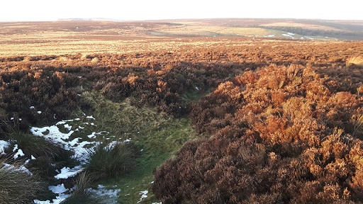
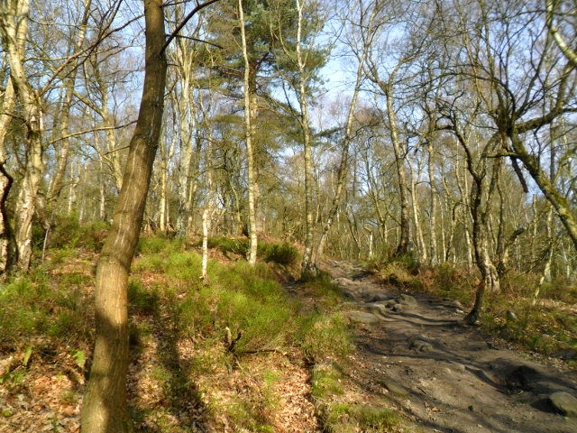
The area we call Blacka Moor is a physically challenging area, though brambles and even bracken are less fierce in 2017. It consists of two distinct parts, Blacka Moor and Totley Moor.
Blacka Moor is the northern part, cut by two streams with steep sided valleys. The northern and eastern parts of this area are a mixture of deciduous woodland, with some bramble and bracken and open moorland with bracken, bilberry and heather, but with a good track network. The southern part of this area is mostly open moorland but with some open pasture, making for faster running.
Totley Moor is the southern part of the area, mostly wild open moorland with heather or moor grass, but with many pits towards the eastern edge of the area.
The area is exposed and competitors should be dressed appropriately in the event of cold or wet weather.