Regional Event
- When:
- Sunday 22 September 2024
- Where:
- Cowms Rocks
- Category:
- Regional
- Final Details:
- View Final Details
- Results:
- View Results
- RouteGadget:
- View RouteGadget
- Splits Analysis:
- View Splits Analysis
- Ranking Points:
- View Ranking Points
Details
So I guess Cowms Rocks doesn't get much harder than it did today, with visibility down to 40m or so - at least it stayed down the whole time so it was the same for everyone.
Richard planned some challenging courses, made all the more harder by the mist, so it was unsurprising to see long times out there. We hope that you enjoyed the challenge, we got lots of nice comments at the finish which are always apreciated, especially from those that didn't manage to complete their course. With the long walk from the parking it felt like a challenge just getting to the start!
Colin did sterling work organising, dealing with the various curve balls sent our way, Thank you to all our helpers especially those that cut their runs short to get back in time, we hope you have dried out, and of course thank you to all of you for coming.
Results and splits and Routegadget are available on the links above.
A pair of boots were left at download, let us know if they are yours
Information
Cowms Rocks offers excellent technical orienteering on a moorland peat plateau. There are sloped areas with a wealth of contour details as a result of erosion and landslides. On a fine day there are stunning views across the Peak District. This event is aimed at experienced orienteers or fell runners with strong navigation skills who enjoy a physical and technical challenge and a good day out in the hills!

How to enter
Entries are open on Fabian4 with self-select start blocks. Maximum entry of 50 participants per course.
There will be no entry on the day. Entries close midnight on Friday 20th September.
Fees
The fees for this event are higher then usual for an SYO event due to exceptional parking and access costs.
Until Sunday 15th September:
Seniors - £15, (£13 British Orienteering Members) including parking
Juniors/Students - £5
£1 surcharge on fees after the 15th.
Volunteers
All members of SYO are strongly asked to volunteer, events do not run themselves!
Helpers receive a 50% discount. Please enter asap on Fabian4 using helper code SYOHELPER and
Parking
Parking at Rowlee Farm 4.4 miles west of Ladybower Inn Signposted off A57.
S33 0BJ, 53.399549, -1.773150, What3Words ///limp.allies.surpassed
NO CAMPERVANS! Please park in the layby alongside Ladybower reservoir and get a friend to pick you up- the parking field is sloped and gates on the narrow side.
The farm track is one vehicle wide you will not be able to leave once you have entered until all cars are parked.
Please take extreme care when leaving and joining the A57 as vehicles travel extremely quickly on this section. The entry is shared with pedestrain route to the area, everyone needs to be courteous and let others pass. You will be able to enter the car park between 9.40am and 11am and exit the car park after 1.15pm. .This is to enable our safety marshalls to run and help!
There are 2 toilets in the farmyard to the west of the parking field.
No Dogs
Unfortunately dogs are not permitted (even in cars) due to sheep in the parking and assembly fields.
Assembly
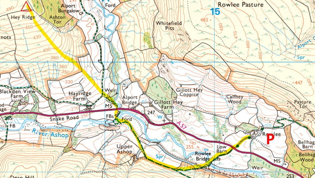
For registration- si card pick up and download and a tent for bag dump at Hayridge Farm. It is 1.6km and 40m climb from the car park along good tracks. There are 2 marshalled crossings of the A57 on route to assemby.
There is a toilet in the nearest farm building. Please use those in the parking area if you can to avoid queues.
You can go straight to the start / finish. Pleasde remember to download on your way back from the finish. See map below for route ( print it out or download to your phone). It is 2.6km and 260m climb from parking to the start. There will be limited taping. please obey the road marshals and take extreme care.
Do not leave Download to return to the parking until 12 30 to ensure crossing marshals are in place.

Start
Start times from 11am to 12.00pm with helper start times before and after the main block. Please choose a 15-minute start block. Given the long walk to the start, these blocks are not being rigidly enforced; you should expect to be able to start soon after you get there. Courses close 2pm promptly. If you think you might take a long time, please select an early start block. There is one start on the top of the plateau. It is a 1km and 220m steep climb through fields from assembly. Please ensure all gates are closed and no sheep let through.
Finish
The finish is adjacent to the start. Clothing / drinks can be left at the finish. In the event of adverse weather a tent will be provided for the clothing dump.
Courses
Due to the nature of the terrain only technically difficult (TD5) courses are available. Provisional course lengths as follows:
Black - 10km 400m climb
Short(ish) Brown - 7.1km 260m climb
Blue - 5.9km 205m climb
Green - 4.7km 125m climb
Short Green - 3.4km, 100m climb
Note: Due to low numbers on Black, Brown and Short Brown we have made the decision to remove the Brown course (This was 8.5km 390m Climb). Short Brown has been increased by 400m and 40m climb.
Planners Notes
Courses are probably on the long side for all but the fittest, so if you think you might be out for a while, perhaps consider dropping down a course. Alternatively, carry some food and water and treat it as a long-O, but if doing so please START EARLY. We will start collecting controls from 2pm promptly even if people are still out.
The courses don't visit the woods, so running in shorts should be fine.
The Short Green is as physically manageable as I could make it whilst still having a technically challenging course. There is one steep descent, into the landslip area, and one steep climb out of it.
Competent Light Green runners could consider tackling Short Green, but if the weather on the day is bad we would strongly recommend only doing so if accompanied by an experienced adult.
Dark Peakers and other fell running variants are very welcome to come and practice their navigation, and will hopefully find it a suitable and enjoyable challenge. Required skills include being able to follow a compass accurately and knowing when you're beaten. As a rough guideline, unless you are used to navigating using orienteering maps, you will probably not average much faster than 10 mins per km over the course as a whole. For further reference, I'd expect Jonny Crickmore to take 70 to 80 mins on the 10km Black.
Map

Map from previous event above
1:10,000, 5m contours. Peel Land surveys 2019. Updated Pete Tryner 2021 mainly to indicate runnability on the moorland - see below.
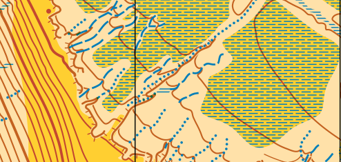
There will be an enlarged section of slippage area (shown above) at 1:5000 in the bottom left corner of the map to aid navigation in this area.
Note that earthbanks, ditches and narrow marsh symbols have all been used to help visualise the peat groughs. Steep peat bank lines are shown with an earthbank symbol, the ditch symbol generally indicates a deep grough with the narrow marsh symbol indicating a more shallow grough.

The open land symbol is used to show open land (see extract below) where running speed could be 80% or more (if you're a young strong runner!), rough open indicates a slower speed, mainly due to longer grass, heather and bilberry. Just like the marsh and seasonal marsh the usage is generalised i.e. it should be used for route choice decisions rather than fine navigation! Generally there is good runability on the edges of the plateau and the flat areas on top getting worse as the angle increases with the heads of the valleys tending to have larger areas of heather. There are some small patches of burnt / mown heather but they are not mapped and do not impact route choice.

Control descriptions on front of map. Loose descriptions on waterproof paper also available.
Terrain
Cowms Moor below Cowms Rocks is a fascinating highly contoured area of old-land-slip ground above the A57 west of Ladybower Reservoir. The map also includes moorland between Oyster Clough and Alport Valley. The plateau is at 500m above sea level and has a network of intricate ditches/gullies and runnable/marshy moorland. The marshes are quite dry and are fairly runnable. There are a number of sheeptracks particularly along the top of the steeper slopes.
There are lots of sheep on the area and whilst planning we have seen a few cows often in the intricate area beneath Cowms Rocks or futher down the valley.

Additional Event Information / Safety
Whistles compulsory. In bad weather waterproofs will also be compulsory and will be advised in the car park. Mobile signal is very poor in parking, assemby and on the area itself.
Event Officials
Organiser: Colin Drury
Planner: Richard Baxter
Controller: Pete Tryner
Safety & risk
A comprehensive risk assessment will have been carried out by the organiser, but participants take part at their own risk and are responsible for their own safety during the event. If a competitor has a pre-existing medical condition that they think should be declared, please complete a medical form at enquiries. The sealed envelope will only be opened in an emergency.
Photography
SYO has an agreed policy on the taking of photographs at events, based on national guidance. This provides a sensible balance between the benefits and risks associated with the taking and use of images. If you are unsure about acceptable practice, please speak to the event organiser. Read our photography policy.
Privacy
When entering our events your personal details (name, gender, age class & club) will appear in the results section of this website. Read our privacy policy to see how we look after your personal data.
Venue
Cowms Moor below Cowms Rocks is a fascinating highly contoured area of old-land-slip ground above the A57 west of Ladybower Reservoir. The map also includes moorland between Oyster Clough and Alport Valley,
