Dusk Event
- When:
- Wednesday 5 October 2022
- Where:
- Stanage Edge
- Category:
- Local
- Results:
- View Results
- Splits Analysis:
- View Splits Analysis
Details
Probably the trickiest area we use! Hope you all enjoyed your run / adventure in the plantation the evening. Things definitely got harder once they turned out the light... Well done to everyone for getting out under inclement conditions, fading light and reasonably high bracken.
Big thank you to Bronwen for planning and Colin Best for controlling and to Ryan Elliot for updating the map after the felling due to Larch Disease (shame we didn't get to hold an event before it was felled) . Also thanks to our helpers Jill, Peter, Jacky, Euan, Joe Woodley, Nick, Sam and John Doyle, Pauline and Pete.
Information
Join us for sprint style races through this wonderfully varied little area below Stanage Edge, which has not been used previously for an orienteering event. Intricate rock features nestle in open moorland and through a scattering of pine and beech trees, providing an excellent level of technical challenge to experienced orienteers. There are also courses suitable for newcomers.


How to enter
All entries must be made in advance on the SYO Entry System. Entries close 12 noon on Tuesday 4th October. There will be no entry on the day.
Parking
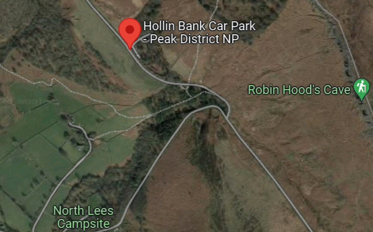
Please park at the Hollin Bank Car Park. Grid reference SK236837. Postcode navigation is not reliable, official car park address is S32 1BR, but on Google Maps S32 1DZ is closer. What3words: inspector.reform.saves.

Starts
The start is 300m uphill from the car park. Yellow starts from 5.30pm. All other Starts 5.45pm to 6.45pm. Courses close 7.45pm promptly. If you think you might take a long time, please come early.
Please note we have had far more entries than expected so there may be a bit of a wait to start. We will try to start people on all courses from 5.30pm or maybe earlier if all the controls are out.
Sunset is 6.33pm so late starters will definitely need a headtorch.
Clothing & Equipment
Headtorch recommended for all just in case you take longer than you expect. Full leg cover and shoes with good grip required for participants on orange, green & blue. Please also carry a whistle.
Facilities
There are public toilets 200m along the road past the finish.
Finish and download are located in the car park.
Courses
Yellow - Easy navigation - 1.1km. 11 controls. Ideal for younger juniors.
Orange - Navigation of medium difficulty - 1.5km. A good place for adult beginners to start. 18 controls
Green - Navigationally hard - 2.3km, 24 controls.
Blue - Navigationally hard - 2.8km, 27 controls.
Distances are straight line route through terrain - you will run further than the distances stated. Although the courses are short the terrain is physical and there is a lot of climb.
Parent shadowers are encouraged for inexperienced juniors.
SI controls and timing will be used. Controls will be SIAC enabled.
There will be loose control descriptions.
Please note - there are lots of controls and butterfly loops. Please take care to visit the controls in the right order!
Map

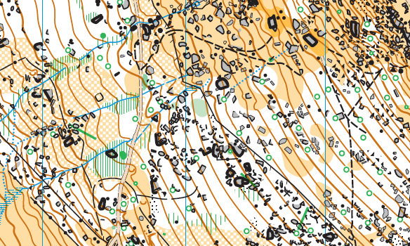
Original map by Pete Tryner & Dom Dakin. Updated 2022 by Ryan Elliot. 1:4000, 2m contours.
Full leg cover essential on orange and above.
Costs
£6 adults (£5 members), £3 juniors & students. Pairs / family groups pay for one entry, extra map £1. Dibber hire free.
Volunteers
We need volunteers, including control collectors, to enable this event to go ahead. If you can help in any way, please
Event Officials
Planner - Bronwen Doyle
Organiser -
Mentor - Colin Best
Series Co-ordinator - Pauline Tryner - pauline'at'southyorkshireorienteers.org.uk
Safety & risk
A comprehensive risk assessment will have been carried out by the organiser, but participants take part at their own risk and are responsible for their own safety during the event. If a competitor has a pre-existing medical condition that they think should be declared, please complete a medical form at enquiries. The sealed envelope will only be opened in an emergency.
Photography
SYO has an agreed policy on the taking of photographs at events, based on national guidance. This provides a sensible balance between the benefits and risks associated with the taking and use of images. If you are unsure about acceptable practice, please speak to the event organiser. Read our photography policy.
Privacy
When entering our events your personal details (name, gender, age class & club) will appear in the results section of this website. Read our privacy policy to see how we look after your personal data.
Venue
This is a new area for 2020. The initial map is Stanage Plantation, which despite its name has no regimented spruce but a variety of trees, primarily beech and pine. The plantation includes runnable woodland and intricately mapped rock features.
