Give orienteering a go - explore the city
- When:
- Sunday 20 March 2022, 10:00 - 17:00
- Where:
- SHAFF
- Category:
- Other
Details
We are teaming up with SHAFF, the Pollen Market and the Outpost to provide an exciting opportunity for visitors to the Festival of the Outdoors to give orienteering a go for free!
Location
We will be based at the Outpost from 10am to 5pm (adjacent to the Showroom theatre). Pay us a visit to collect a paper map and find out how to use Maprun. We can also tell you a bit more about orienteering and the club.
Outpost - The Workstation, Paternoster Row, Sheffield City Centre, Sheffield S1 2BX
SHAFF will be showcasing an exciting programme of films at the Showroom and there are activities and stalls 10am to 5pm at both the Outpost and The Pollen Market , so you can check these out before or after the orienteering.
Cost
Free
Who's it for?
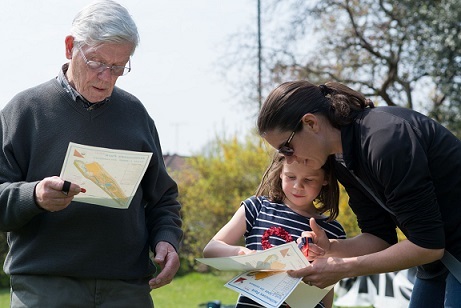
Anyone can have a go at orienteering. Choose your route and run, jog or walk at your own pace in groups or as an individual. We think families will enjoy this course, which visits key Sheffield landmarks and the Pollen Market. Equally it will also appeal to good runners, who can challenge themselves to see if they can get all 40 controls within the 90 minute time limit.

How it works
Come & visit our friendly volunteers at the South Yorkshire Orienteers stall at the Outpost anytime between 10am and 5pm. We will explain what to do and give you a map. The aim is to navigate to the different controls (checkpoints) marked on the map. You have 90 minutes to visit as many controls as you can - the more you visit, the more points you score. You score 20 points for each control you visit but take care not to be late back as you lose 10 points for each minute your late back.
The course and map will be on the Maprun App. We suggest you download this before you arrive but don't worry if you don't have chance - we will be on hand to help.
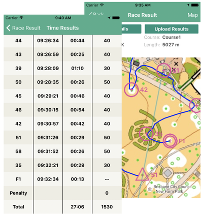
When you arrive at a checkpoint the app will beep to notify you. It also keeps a tally of the points you score and shows the route you've taken. If you don't have a smart phone, you can just use the paper map.

Safety Info
Due to numerous busy road crossings, under 16s should be accompanied by an adult. Please take care crossing roads and tram tracks. All participants take part at their own risk.
Using Maprun
If you want to find out more about how to use Maprun before you come, here is a guide.
MapRun is FREE and easy to use.
To start your adventure, install the 'MapRun6' app for iOS or Android:


- If you're at one of our MapRun events, scan the QR code provided, and the course will load automatically!
- If doing a course in your own time... Start the App
- Enter your Name - this will be published in the results at the end - it can be changed in the future
- Tap Select Event and browse to the 'UK' > 'South Yorkshire' folder. There you can select the course you want to run (you can do this at home using wifi)
- Alternatively, tap Events Near Me to display a list of events near your current location (works best if using data, once you're near the start)
- There's a list and map of MapRuns available locally on this page. In the list there are links to PDFs of each course. If you'd prefer to navigate using a paper map rather than the phone, feel free to print these!
We offer 2 types of courses: Linear (normal) or Score. Details of what courses are offered at each location are given in the map and list.
In a Linear course you must follow round all the controls (checkpoints) in order, going from the Start (Triangle), to 1, 2 3 etc. all the way round to the Finish (Double Circles). With the MapRun app you'll get a beep every time you reach a control. Your time starts at the Start, and ends at the Finish. On MapRun, we've planned a number of relatively easy Yellow courses in some of Sheffield's parks, that stay just on paths or well-cut grass. There's also the odd White course which is easier and shorter than a Yellow.
Contrastingly, in a Score you've got to plan the best route to try and visit as many controls as you can within a certain time limit. On MapRun it's usually an hour, but there are much shorter (and longer!) scores. You get 20 points for each control you find, but lose 10 points for every minute you are late back. Just like with the linear courses, your time still starts at the Start, and ends at the Finish - but what you do between these points is up to you! Top tip: don't run past the Finish until your ready to stop your time - otherwise the phone might think you want to end your course early!
The symbols used on an orienteering map are quite different from Ordnance Survey maps, and can take some getting used to.
To help you out, some maps (especially the Park ones) have a key (or legend) on the map - both in the app, and one you might print out. However some of the larger urban and moorland area maps may not have a legend, so use the following links to download a key to all the different colours and symbols used. Don't worry if it looks complicated at first, just concentrate on the main features of the map you're going to use - you'll soon have mastered them!
Legend for Forest/Moorland maps
- Tap Go to Start to see the map and course
- You may need to 'Allow' GPS access
- The app will connect to GPS, and the status is given in the coloured bar at the bottom. It may take your phone a moment or two to locate enough satellites, in which case the bar will be red, indicating low accuracy.
- Once the bar turns green, you're ready to go!
- You then need to run or walk through the Start Triangle (on the map) to trigger your time to start!
- As you go round your course, make sure you hear a beep at each control - you may need to wait for a few seconds for the GPS to catch up if you're speedy! The controls will turn from pink to green on the map once punched.
- If you get lost, don't panic! The app should be able to show you where you are :)
- At the end of your course (Linear or Score) pass through the Finish to stop your time. A screen will appear showing you your route and time.
- At the finish, MapRun will automatically upload your results (if you've got data), or you can do it yourself later (over wifi). You can also send your results to Strava. Please do upload your result, as it lets us know which courses are popular!
- Finally, you can compare your result with others who did the same course, by tapping All Results for this Event.
- Well done - you've completed a MapRun course!


Safety & risk
A comprehensive risk assessment will have been carried out by the organiser, but participants take part at their own risk and are responsible for their own safety during the event. If a competitor has a pre-existing medical condition that they think should be declared, please complete a medical form at enquiries. The sealed envelope will only be opened in an emergency.
Photography
SYO has an agreed policy on the taking of photographs at events, based on national guidance. This provides a sensible balance between the benefits and risks associated with the taking and use of images. If you are unsure about acceptable practice, please speak to the event organiser. Read our photography policy.
Privacy
When entering our events your personal details (name, gender, age class & club) will appear in the results section of this website. Read our privacy policy to see how we look after your personal data.
Venue
We haven't added any description of this venue yet, but you can still click the link below to see previous events that were held here.