Regional Event
- When:
- Sunday 17 December 2017
- Where:
- Blacka Moor - Sheffield
- Category:
- Regional
- Flyer:
- View Flyer
- Final Details:
- View Final Details
- Results:
- View Results
- RouteGadget:
- View RouteGadget
- Splits Analysis:
- View Splits Analysis
- Ranking Points:
- View Ranking Points
- Other:
- View Other
Details
What a difference a day makes! Blacka in the sun yesterday. If only it'd been like this on Sunday.
However, despite the horrendous weather, many hardy souls still came and thoroughly enjoyed Aislinn's challenging courses. The inside assembly area and Jacky's cake stall provided welcome refuge from the elements.
Thank you to Peter Gorvett for controlling, Aislinn Prendergast for planning, Brian Shaw for organising, SI manager Dom Dakin and to all on-the-day helpers.
Results now available (16:00 Sunday)
Results, Routegadget, Winsplits (Splits Analysis), & Splits (Other)
Any problems let me know:
Data uploaded to British Orienteering, ranking points available tomorrow (22:10 Sunday)
-----------
Saturday update:
There is still snow on Blacka. Putting out controls this afternoon most of the area has about an inch or less, so minimal impact on runnability. Some of the higher areas have more than this, but most will find only very short stretches that will significantly slow them. It looked great, especially with a glorious sunset.
Orienteering on beautiful Blacka - an event suitable for experienced orienteers and newcomers.
Final details below and in downloadable form above.

Location: Blackamoor is 8km SSW of Sheffield.
Parking: At Dyson Technical Ceramics site at GR SK 296790 on the A621 Baslow Road 8km SSW of Sheffield and 1km N of the Owler Bar roundabout. S17 3BL.
There is ample hard standing and NO PARKING FEE.
Do not enter any derelict buildings.
Take care entering and leaving, the A621 is a busy road.
Toilets, a hot drinks & mince pie stall and a warm inside registration / enquiries / download area!
EOD: Pre-entry is closed but EOD at no extra charge.
Seniors £8 (£10 non BOF members)
Juniors/students £4
Family £20 (£24 non BOF members)
Family fee = 2 senior +1 or more junior
Juniors/Students/ Adults on courses up to Long Orange £4
Families running with one map and dibber £4
SI card hire: £1 Lost SI card compensation: £30
There should be enough maps for everyone to run the course they choose.
PLEASE arrive EARLY if you think you might be out a long time.
Times: Registration 10:00 - 12:00
Starts: 10:30 - 12:30 Courses close: 14:30
Crossing points: The area is criss-crossed by a number of walls and fences which must only be crossed at marked crossing points. This affects all courses except white and yellow. . These are all overprinted with the thick purple uncrossable boundary symbol. However, to avoid control descriptions being exceptionally long, the instructions to use crossing points on each occasion are omitted on the most technical courses. Crossing an uncrossable boundary will lead to disqualification.
Most of the crossing points are permanent gates and stiles and have no additional marking. However two involve climbing a gate or wooden rails. These crossing points will be indicated with red/white tape.
There are also ruined walls on the map that can be crossed at any point.
Dogs: Welcome in the car park but not on courses
Start: The pre START (X) is 500m from the car park with 70m climb, allow at least 15 minutes, and is fairly sheltered. The map boxes and start punches are a bit further up the track (I). The start kite itself will be a further 100m up the hill and clearly visible from the start.
[Downloadable final details include a map of start/finish area]
Finish: 500m to the car park downhill. The route from the FINISH goes close to the pre Start so clothing may be left at the pre start. There will be no clothing transfer.
Download: At Registration. You must report to download even if you have retired to prevent a search party having to be sent out.
Control Description: In the Start lanes on waterproof paper and printed on the map. White and Yellow courses have text control descriptions. Orange courses have pictorial on the map and text on the loose versions. Other courses are all pictorial.
Terrain: Blackamoor is mostly open heather moorland with some mixed forest on steep valley sides making for challenging orienteering both technically and physically. Some bracken but most was flat even before the recent snow. The forest areas seem more runnable than at previous events, presumably due to bramble management by Sheffield Wildlife Trust.
Map: 1:10000 with 5m contours. Significant update by Peter Gorvett including use of Lidar in some key areas autumn 2017. A lot of the slow run bramble screen in the woods has been removed thanks to work by the Wildlife Trust.
Sizes: Black/Brown A3 double sided, Blue: A3 Single Sided, All other courses: A4
Safety: Much of Blackamoor is above 1000ft and very exposed, please come prepared with waterproof jacket, hat and gloves. Hopefully most of the snow will have gone and perhaps flattened the remaining high bracken. Sunday looks like being a little warmer than of late but hypothermia is a real danger especially if it rains. PLEASE COME PREPARED.
Whistles should be carried.
First Aid: At Registration. The nearest hospital/A&E department is at Chesterfield Royal Hospital, Calow, Chesterfield S44 5BL. Tel. 01246 277271.
Cancellation: In the event of possible cancellation see: www.southyorkshireorienteers.org.uk
Officials: Planner: Aislinn Prendergast (SYO)
Controller: Peter Gorvett (SYO)
Organiser: Brian Shaw (SYO) 07768 928432 email: drgbshawATgmaildotcom
This is a YHOA SuperLeague Event. Standard courses are suggested below, but points are scored whichever course you run. For the complete rules see www.yhoa.org.uk
M21 Black
M18,M20,M35,M40,M45,M50, W21 Brown
M16, M55,M60, W18,W20, W35,W40 Blue
M65, M70, W16, W45,W50,W55,W60 Green
M75,M80, W65,W70, W75,W80 Short Green
M14/W14 Light Green
M12/W12 Orange
M10/W10 Yellow
Course Details:
|
Black |
9700 m |
460 m |
19 Controls |
|
Brown |
8340 m |
455 m |
17 Controls |
|
Blue |
5400 m |
240 m |
11 Controls |
|
Green |
3730 m |
145 m |
9 Controls |
|
Short Green |
3410 m |
165 m |
10 Controls |
|
Light Green |
3190 m |
140 m |
7 Controls |
|
Long Orange |
4570 m |
195 m |
13 Controls |
|
Orange |
2720 m |
110 m |
8 Controls |
|
Yellow |
2640 m |
70 m |
8 Controls |
|
White |
1950 m |
50 m |
8 Controls |

Safety & risk
A comprehensive risk assessment will have been carried out by the organiser, but participants take part at their own risk and are responsible for their own safety during the event. If a competitor has a pre-existing medical condition that they think should be declared, please complete a medical form at enquiries. The sealed envelope will only be opened in an emergency.
Photography
SYO has an agreed policy on the taking of photographs at events, based on national guidance. This provides a sensible balance between the benefits and risks associated with the taking and use of images. If you are unsure about acceptable practice, please speak to the event organiser. Read our photography policy.
Privacy
When entering our events your personal details (name, gender, age class & club) will appear in the results section of this website. Read our privacy policy to see how we look after your personal data.
Venue
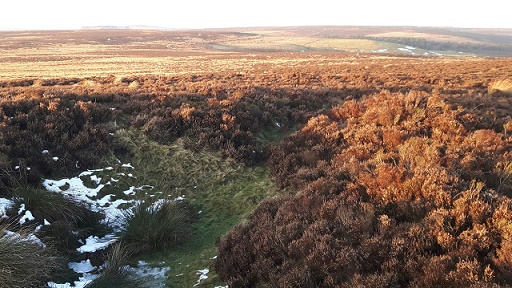
The area we call Blacka Moor is a physically challenging area, though brambles and even bracken are less fierce in 2017. It consists of two distinct parts, Blacka Moor and Totley Moor.
Blacka Moor is the northern part, cut by two streams with steep sided valleys. The northern and eastern parts of this area are a mixture of deciduous woodland, with some bramble and bracken and open moorland with bracken, bilberry and heather, but with a good track network. The southern part of this area is mostly open moorland but with some open pasture, making for faster running.
Totley Moor is the southern part of the area, mostly wild open moorland with heather or moor grass, but with many pits towards the eastern edge of the area.
The area is exposed and competitors should be dressed appropriately in the event of cold or wet weather.